
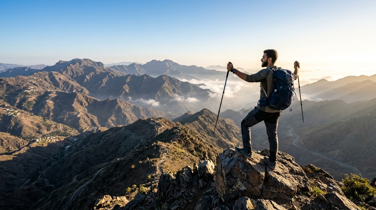
Standing at 3,015 meters (9,892 feet), Jabal Sawda is the tallest point in Saudi Arabia and the crown jewel of the Asir mountain range. Unlike the sand dune images that dominate most travelers’ mental pictures of the Kingdom, this peak sits in a cool, green highland where juniper forests blanket the slopes and mist rolls through the valleys. Hiking here feels like stepping into a completely different country. The air is thin, the views stretch across the Asir escarpment toward the Red Sea, and the trail rewards you with a sense of accomplishment that few other Saudi adventures can match.
Jabal Sawda is a moderate to challenging day hike in Saudi Arabia’s Asir region near Abha. The summit trail is roughly 6 kilometers round trip with 350 meters of elevation gain. Best hiked between October and March when temperatures are cool. No official permit is required, but you need a rental car or taxi from Abha. The trail is unmarked in sections, so download offline maps before you go.
Why Jabal Sawda Belongs on Your Saudi Bucket List
Most visitors to Saudi Arabia stick to the central deserts, the Red Sea coast, or the historical sites of AlUla. The Asir region remains a hidden gem, and Jabal Sawda is its centerpiece. What makes this hike special is the contrast. One moment you are walking through a dense juniper forest with birdsong all around you. The next you are standing on a rocky summit looking down at clouds that have settled in the valleys below.
The peak sits near the city of Abha, which is already worth a visit for its cable cars, traditional mud-brick villages, and cool climate. Adding the Jabal Sawda hike turns a standard city stop into a genuine outdoor adventure. For hikers who want to claim the highest point in any country, this is the only game in town in Saudi Arabia.
When to Plan Your Jabal Sawda Hike
Timing matters more here than on most hikes. The Asir region gets serious rainfall, and summer temperatures at the summit can still reach uncomfortable levels despite the altitude.
October through March is the sweet spot. During these months, daytime temperatures at the trailhead hover between 10 and 20 degrees Celsius (50 to 68 degrees Fahrenheit). Mornings are crisp, and the air feels clean. You will also catch the tail end of the rainy season, which means the juniper forests are at their greenest.
April and May are transitional months. The weather is still okay, but fog becomes more common. Visibility at the summit can drop to near zero if you hit a thick cloud bank.
June through September bring higher temperatures and more humidity. The hike is still doable if you start very early, but it is less pleasant and you will sweat through your gear before you reach the top.
A note on fog: Jabal Sawda sits at an elevation where clouds frequently form. Do not be disappointed if you summit and see nothing but white. The hike itself is still beautiful, and the views often clear by late morning.
Getting to the Trailhead
The trail to the summit starts near the Jabal Sawda park area, about a 30-minute drive from central Abha. You have two options for getting there.
Renting a car is the most flexible choice. The drive from Abha takes you southwest on Route 10 toward the village of Al Souda. The road is paved and in good condition. A standard sedan can handle it without issues, though a car with a bit of ground clearance gives you more confidence on the unpaved sections near the park entrance. For guidance on renting vehicles in the Kingdom, check out our guide on renting a car in Saudi Arabia.
Hiring a taxi or ride-share works if you do not want to drive. Drivers in Abha know the route well. Negotiate a round-trip fare with a waiting time built in, since cell service can be spotty at the trailhead if you need to call for a pickup.
The GPS coordinates for the main parking area are approximately 18.2525 N, 42.6800 E. Save these before you leave Abha.
What to Expect on the Trail
The Jabal Sawda hiking guide trail is not a manicured path with signposts every hundred meters. It is a rugged, semi-wilderness route that requires basic navigation skills.
Trail distance and elevation: The round trip from the parking area to the summit is about 6 kilometers (3.7 miles). You gain roughly 350 meters (1,150 feet) of elevation. The climb is steady but not punishing. Most hikers with moderate fitness complete the round trip in 3 to 4 hours, including time at the top.
Trail surface: The first section is a wide dirt track that winds through juniper woodland. After about a kilometer, the trail narrows and becomes rockier. The final push to the summit involves scrambling over loose scree and boulders. Good ankle support is essential.
Navigation: The trail is not marked with official signs. You will find occasional cairns (small piles of rocks left by previous hikers) that mark the route, but they are easy to miss. Download an offline map app like Maps.me or Gaia GPS before you go. The trail is visible on satellite imagery, so you can follow your GPS track even if the physical path disappears.
Crowds: This is not a busy trail. On a weekday in the off-season, you might have the entire mountain to yourself. Weekends and public holidays see more local families picnicking near the base, but the summit rarely feels crowded.
What to Pack for the Summit
The weather on Jabal Sawda can change in minutes. You might start hiking in warm sunshine and end up shivering in a cold wind at the top.
- Footwear: Hiking boots with good tread. The scree near the summit is loose, and trail runners will leave you slipping.
- Layers: A base layer, a fleece or lightweight puffy jacket, and a windproof shell. The summit wind is no joke.
- Water: Bring at least 2 liters per person. There are no water sources on the trail.
- Snacks: High-energy food like nuts, dried fruit, or granola bars. A sandwich for the summit makes the experience better.
- Sun protection: Sunscreen, sunglasses, and a hat. The UV exposure is stronger at altitude.
- Navigation tools: A fully charged phone with offline maps, plus a portable power bank.
- First aid kit: A small kit with blister treatment, antiseptic wipes, and pain relievers.
The most common mistake hikers make on Jabal Sawda is underestimating the wind at the summit. Even on a calm day in Abha, the peak can have sustained winds of 30 to 40 kilometers per hour. That wind chill drops the effective temperature by 5 to 10 degrees Celsius. Bring a windproof layer even if the forecast looks warm.
Difficulty Level and Fitness Requirements
This hike sits firmly in the moderate category. It is not technical. You do not need ropes, climbing gear, or any special training. But it does require a baseline level of fitness and comfort with uneven terrain.
Who will find this hike easy: Regular hikers, trail runners, and anyone who exercises several times a week. The elevation gain is spread out enough that it never feels like a wall.
Who will find this hike challenging: Occasional walkers, people with ankle or knee issues, and anyone not used to hiking at altitude. The thin air at 3,000 meters makes you breathe harder than you expect. Take breaks. Go slow. There is no shame in turning around if you feel unwell.
Who should skip it: Anyone with respiratory conditions, serious joint problems, or a fear of heights on exposed rocky terrain. The summit area has some steep drop-offs.
Permits, Fees, and Regulations
One of the best things about this hike is the simplicity of access. As of 2026, you do not need a special permit to hike Jabal Sawda. There is no entry fee for the trail itself. The parking area is free.
What you do need is a valid tourist visa for Saudi Arabia. The e-visa process takes about 10 minutes online, and the visa covers the entire country including the Asir region.
A few unofficial rules to follow:
– Pack out all trash. There are no bins on the trail.
– Do not disturb the juniper trees. They are protected.
– Be respectful if you encounter local families having picnics near the trailhead. A friendly greeting goes a long way.
Common Mistakes Hikers Make
Even experienced hikers can run into issues on Jabal Sawda if they do not prepare properly. Here is a table of the most common errors and how to avoid them.
| Mistake | Why It Happens | How to Avoid It |
|---|---|---|
| Starting too late in the day | Hikers assume a short trail means a short time commitment | Start by 8:00 AM. Fog often clears by late morning, and afternoon thunderstorms can roll in during spring. |
| Underestimating the wind | Abha feels calm, so hikers leave jackets in the car | Check the mountain forecast specifically, not the city forecast. Bring a wind shell regardless. |
| Relying on phone signal for navigation | Cell towers do not cover the summit area | Download offline maps before you leave Abha. Carry a power bank. |
| Not enough water | The cool air masks how much you are sweating | Drink before you feel thirsty. Sip regularly. |
| Wearing cotton clothing | Cotton stays wet against your skin when you sweat | Wear synthetic or wool base layers. Cotton kills at altitude. |
Where to Stay Before and After the Hike
Abha is your base camp for the Jabal Sawda hike. The city has a good range of accommodation, from international hotel chains to local guesthouses.
For convenience: Stay in the Al Souda area on the southwestern edge of Abha. It is closer to the trailhead and surrounded by the region’s famous fog-shrouded mountains. Several new resorts have opened here in the last few years.
For budget travelers: Central Abha has affordable hotels and hostels. The drive to the trailhead is only 30 minutes.
For a unique experience: Look into traditional Asiri-style guesthouses in the mountain villages near Abha. These offer a cultural immersion that complements the hiking adventure. The Asir region has a distinct architectural and culinary identity that sets it apart from the rest of Saudi Arabia.
Combining Jabal Sawda with Other Asir Adventures
If you are traveling all the way to southwestern Saudi Arabia, do not limit yourself to a single hike. The Asir region has several other outdoor experiences that pair well with the Jabal Sawda summit.
- Abha cable car: The longest cable car ride in the Middle East. It drops down into a valley with traditional villages and terraced farms.
- Rijal Almaa village: A UNESCO-recognized heritage village with stone and mud-brick towers. It is about an hour from Abha.
- Al Souda Nature Reserve: A protected area with hiking trails, picnic spots, and viewpoints that look out over the escarpment.
- Saturday market in Abha: A lively souq where you can buy local honey, spices, and handmade crafts.
For more ideas on what to do in the area, read our complete list of hidden gems in Saudi Arabia.
Safety Considerations
Saudi Arabia is a safe country for tourists, and the Asir region is no exception. Crime rates are extremely low. The main risks on this hike are environmental.
- Altitude sickness: Symptoms include headache, nausea, and dizziness. If you feel any of these, descend immediately. Most people are fine at 3,000 meters, but listen to your body.
- Fog and low visibility: If you are caught in thick fog, stop moving. Use your GPS to confirm your location. Wait for visibility to improve before continuing.
- Loose rocks: The scree near the summit is unstable. Step carefully. Test each foothold before putting your full weight on it.
- Wildlife: You might see baboons near the trailhead. Do not feed them. They can be aggressive when they associate humans with food.
Your Summit Checklist
Here is a final checklist to run through the night before your hike.
- Weather forecast checked for the mountain (not just Abha city)
- Offline maps downloaded on your phone
- Power bank fully charged
- 2 liters of water packed
- Windproof jacket in your pack
- Sturdy hiking boots broken in
- Sunscreen applied before starting
- Snacks and lunch packed
- Someone knows your hiking plan and expected return time
Making the Most of Your Summit Moment
When you reach the top of Jabal Sawda, take a moment to sit and absorb the view. The summit is a rocky plateau with enough space to find a private spot. The sense of standing on the highest point in an entire country is rare. Only a handful of places on earth let you claim that title.
The return hike goes faster than the ascent. Watch your footing on the loose sections. Your legs will be tired, and that is when most people twist an ankle.
Back at the car, drive to one of the small restaurants in Al Souda for a hot meal. Local dishes like aseed (a wheat porridge with meat and vegetables) or lamb mandi will refuel you properly. The combination of physical exertion, cool mountain air, and good food is the perfect way to end a Jabal Sawda hiking guide adventure.
Your Next Steps for Hiking Saudi Arabia’s Highest Peak
You now have everything you need to plan and execute a successful Jabal Sawda summit. The hike is accessible, rewarding, and surprisingly unknown among international travelers. That is changing as more people discover Saudi Arabia’s outdoor potential.
Start by booking your flight to Abha. From there, it is a short drive to the trailhead. The mountain is waiting. All you have to do is show up prepared, respect the environment, and take that first step onto the trail. The summit views and the bragging rights of standing on the roof of Saudi Arabia will take care of the rest.